How Maui's Wildfire Ash Impacted Local Reefs

Andrea Dingeldein
When wildfire tore through the Hawaiian beach town of Lahaina last August, it took at least 100 lives and more than 2,200 buildings—including the majority of the town’s nearly 1000 businesses. It took shelter from more than 7,000 residents on Maui’s western coast. It took cars from the road and boats from the harbor.
What the blaze left was ash. Lots of ash. And, given that so much of the burn zone was a built environment, it’s packed with contaminants like arsenic, lead, antimony, cobalt and copper. Removing this much debris [1] [2] [3] [4] [5] [6] is complicated, and the search for a final containment site is stoking fierce debate among concerned residents.
In the meantime, these contaminants pose a number of threats to the health of the community—and its reefs. As the contaminated soil runs off in heavy rains, it can harm corals that stand to play a major role in the community’s long-term recovery. Economically, yes, given that $3 billion in annual tourism spending on Maui supports 75% of the island’s private sector jobs. But healthy reefs also provide a spiritual, social and nutritional backbone upon which the community relies.
Related Reading: Divers Cull the Tide of Urchins to Help Save Kelp
“There is a ‘ōlelo no'eau, or proverb, in Hawaii that says “‘E ola ke kai, E ola kākou.” ’ This means ‘As the sea thrives, so do we,’” says Manuel Mejia, Regional Program Director of the Hawaiian Islands for the Coral Reef Alliance. “Our wellbeing is directly dependent, and vice versa, because healthy coral reefs benefit healthy coastlines... The equation in my mind is healthy corals equals healthy people.”
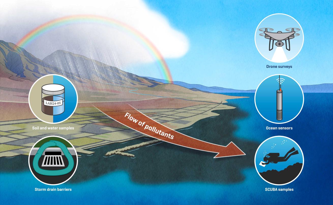
In the immediate aftermath of the fire, barriers were installed around storm drains to capture debris and filter runoff, but that doesn't prevent unfiltered runoff entering from streams or the wind from whipping beach ash into the sea. Hawaiian residents are working hard to monitor how the tragedy on land may be impacting life below the waves. Citizen scientists are filming runoff with drones, government scientists are collecting samples and academics are partnering with private enterprises to capture in-situ data.
The State of Hawaii Department of Aquatic Resources began collecting soil samples shortly after the fire, before any major land shifts. Renee Takesue—a research geologist with the U.S. Geological Survey (USGS) Pacific Coastal and Marine Science Center in Santa Cruz, California—collected soil samples throughout the town in mid-January. Her samples span land uses, including agricultural lands, industrial sites, parks, neighborhoods, the historic downtown, reef substrate within 15 feet of the shore and control sites that were not impacted by the fire.
There, in between two big rainstorms, she saw runoff streaming across the town and beaches, debris coming from culverts, and ash buried in beach sands. She is looking out for polycyclic aromatic hydrocarbons (PAHs), several of which are carcinogens regulated by the Environmental Protection Agency. They come from a wide variety of sources, including vehicle emissions and barbecue char, and “wildfires have distinct signatures in their chemical compositions,” says Takesue. “I can tell when I look at PAHs in the beach sediment or coral reef, I can tell if it came from the wildfire, or if it’s industrial activity or just traffic pollution.” This will offer a preview of what is likely entering the ocean.
Out on the water, Dr. Andrea Kealoha, of the University of Hawaii at Manoa School of Ocean and Earth Science and Technology, and a multidisciplinary team are watching how this is unfolding in real time.
While her colleagues are testing for pollutants, Kealoha is watching the water and reef itself. Since receiving a rapid response grant from the National Science Foundation in the weeks following the fire, she has collected hundreds of samples across more than a dozen offshore sites. She also deployed water sensors lent and donated by commercial enterprises like SeaBird Technologies and Sun & Sea Technology. While water sampling captures a moment in time, these sensors are collecting information about temperature, salinity, oxygen, turbidity, water movement and chlorophyll every five minutes. All of this information can be used to look for hypoxia (too little oxygen in the water) or acidification (which can slow the growth of coral skeletons).
“From those data, we're actually measuring what I call the metabolic pulse of the reef, how the reef breathes, and how the growth and breath of the reef actually changes the chemistry of the water,” says Kealoha.
Related Reading: How Spore Banks Can Save Kelp
While “there's definitely going to be some impacts associated with the wildfires,” she says, determining what exactly they are will require long-term monitoring. In the short term, pinpointing any effects is complicated by the fact that, because of the mass displacement, there are fewer human stressors on the reef like tourism and fishing. That is a temporary stress relief on the reef, making the reef’s holistic response to the wildfire “a complicated question.”
As a part of long-term monitoring, USGS scientists are hoping to partner with local divers. They would be able to collect samples directly off the reef for analysis. Alongside spear and commercial fishermen, scuba divers would also be able to collect fish for scientists to identify if toxins are building up in the fish. This would threaten the food security of many on the island who rely on the reef to feed their families.
Divers around the world can contribute by reducing their CO2 emissions, says the Coral Reef Alliance’s Mejia. Droughts exacerbated by climate change turned fallow farm fields into tinder, and hurricane winds strengthened by climate change knocked down the power lines that likely lit the flames. Every bit of warming we prevent will mean everything to communities spared from the effects of our man-made pyrocene.


