How Hurricane Irma Radically Shifted South Florida Wrecks

Ancient Mariner
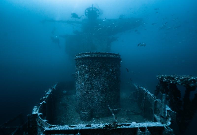
Type: USCG cutter | Length: 165 ft. (50.5 m) | Tonnage: 337 GRT | Construction: Point Pleasant, West Virginia, 1934 | Sunk: June 9, 1991
Blue skies, clear sailing and maybe a minute to toast their first official release. That’s what the creators of the new Reef Smart Guides were expecting as they finished up work on their Barbados dive guide, part of a slate of coming releases that includes Florida’s Broward and Palm Beach counties, the Florida Keys and Bonaire.
And then their phones began to ping.
It was mid-September, and Hurricane Irma — then a Category 4 storm with maximum winds of 130 mph, the most intense hurricane to strike the United States since Katrina — had just steamed over South Florida like a freight train.
With their Broward County dive maps about to begin rolling on the presses, “we started getting frantic emails from some of the dive centers we had worked with to collect the data” for the detailed underwater guides, managing director Ian Popple recalls. “Apparently Irma had produced massive changes in virtually every site — even the deep ones.”
After the initial shock, the Montreal-based trio of Popple, creative director Otto Wagner — the artist behind the well-loved ArtToMedia dive maps — and editorial director Peter McDougall realized they had an opportunity.
“We knew we were going to have to rework the models,” Popple says, “but it struck us that we had accidentally produced a fantastic natural experiment: We have detailed, 3D models of 15 popular wrecks before and after a major hurricane.” (Although too finely detailed to be reflected in Reef Smart’s maps, corals and sponges were damaged too; those effects are still being assessed.)
“Okinawa — the newest site, and therefore one of the more structurally solid — had been facing south at 70 feet,” Popple says. “Irma moved the wreck more than 200 feet across the sand and turned it to face southwest.”

Okinawa
Type: U.S. Army long tug | Length: 107 ft. (34.5 m) | Tonnage: 350 GRT | Construction: New Orleans, 1953 | Sunk: August 19, 2017
Ancient Mariner, also at 70 feet, had its entire above-deck structure sheared off. Initial feedback on a wreck called Rodeo 25 suggested that the whole wreck had collapsed in on itself — “and this is at around 120 feet!” Popple exclaims. Strong storms can generate currents and underwater turbulence that last for up to a week after the storm has passed, with altered currents dismantling wrecks and reefs up to 300 feet deep.
“In North Carolina, we were told that the Spar — another huge wreck — had been moved about 200 feet by Hurricane Irene” in 2011, Popple says. “That wreck is at 110 feet, a giant ship. We thought, ‘Nah, that’s an exaggeration.’ We didn’t really believe the wrecks we had just mapped would change that much.”
They were wrong.
BEFORE AND AFTER
When Reef Smart’s collaborators were able to get in the water after the storm, “they went to the GPS coordinates for Okinawa — and found nothing,” Popple says. When they finally located the 107-foot wreck, the divers were incredulous: It had moved more than 200 feet and was now lying on its side. “This is not an insignificant-size wreck. We said, ‘My God, if Okinawa has moved, what’s happened to the rest of our sites?’”
While the degree of change was awe-inspiring, even small shifts would have been a problem for Reef Smart. Compared with ArtToMedia’s cards, Reef Smart’s guides are “more accurate, more precise, and use a lot more info than previously,” Wagner explains. “A lot more cameras, more visual info, and we also now can take depth soundings that allow horizontal readings between structures.” Thanks to Popple and McDougall — both marine biologists — Reef Smart’s guides also feature site-specific species info.

Captain Dan
Type: U.S. Coast Guard tender | Length: 175 ft. (53.3 m) | Tonnage: 750 GRT | Construction: Bay City, Michigan, 1937 | Sunk: February 20, 1990
The creation process is similar to the old maps — divers gather information with multiple cameras, slates, GPS and even drones — except much quicker. Information is fed in almost real time from divers all over the world to designers in Canada, who model the info in computer-aided design programs like 3D Studio Max.
The very thing Reef Smart hoped would give the new guides value — their wealth of precise, reliable detail — was now in question. Thanks to Irma, they would have to begin again on at least some of the Broward wreck sites.
ONCE MORE, WITH FEELING

Rodeo 25
Type: Coastal cargo ship | Length: 215 ft. (65.5 m) | Tonnage: 495 GRT | Construction: Amsterdam, in 1956 | Sunk: May 12, 1990
Okinawa, which experienced the biggest change, had been purpose-sunk — and surveyed — barely three weeks before the storm. “We asked ourselves, what was unique here?” Popple says. “Okinawa had only just been dropped and was relatively unsettled on the bottom.”
To resurvey Rodeo 25, McDougall dived with Reef Smart’s pre-storm model in hand. “It was quite dramatic to see the entire superstructure of a ship basically pushed over as if by a big hand,” he says.
McDougall had not done the original surveying on Rodeo 25, but he did have the map. “It really reinforced for me the value the maps provide,” he says. “Really being able to see all the details that had changed helped reinforce what we are doing, and how our cards can make diving better. I could understand the value as a diver, being in the water holding a card of a dive I’d never gone on before. It was a good reminder that what we’re doing is useful.”


